EGMS Check
Does satellite InSAR agree with the ground?
Validation of the European Ground Motion Service (Copernicus, Sentinel-1 InSAR) against two independent kinds of ground measurement: permanent GNSS stations in the Groningen gas field and state precise levelling in North Rhine-Westphalia. The rules were fixed before any comparison was computed, and failed rules are reported too.
Key results
- North Rhine-Westphalia: on 1,216 levelling benchmarks EGMS shows the same height change as levelling (slope 0.96, up to −140 mm in 3 years), with the same direction of motion at all 54 benchmarks in subsidence bowls.
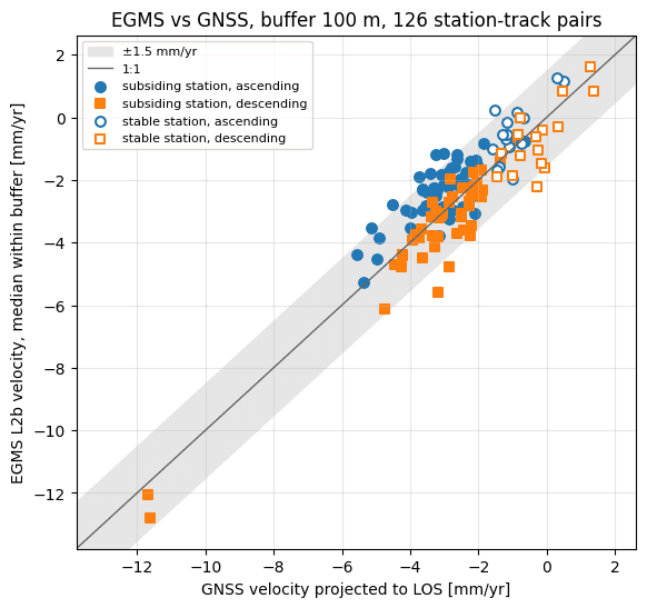
- Groningen: GNSS confirms the EGMS subsidence rate within 1.5 mm/yr for 91% of station × track pairs (EGMS release 2019–2023) and 99% (release 2020–2024).
- Reported as failed: a constant ≈ −2 mm/yr offset to the levelling datum breaks 3 of 4 pre-registered rules, and the stable-station check fails in Groningen.
- One command runs the whole pipeline on a normal computer; offline tests of all modules run in CI on every change.
Articles about this project
EGMS vs levelling in North Rhine-Westphalia: a check without GNSS
I compare EGMS vertical motion with precise levelling on 1,216 benchmarks near open-pit lignite mines in Germany. Part 2 of 2.
EGMS vs GNSS in Groningen: does satellite radar see the same subsidence?
I compare ground motion from the European Ground Motion Service (Sentinel-1 InSAR) with 35 GNSS stations above the Groningen gas field. Part 1 of 2.